England Coast to Coast: Day 18 – The Final Day!

Yay! Hooray! Whoopee! This is me laughing and being giddy which is exactly what happened when I stepped on the beach of the North Sea at Robin Hood’s Bay today. I did it—walked across the whole of northern England- 192 miles. What a great feeling of accomplishment!

The day's start- a back country lane that meandered from village to village. England has tons of these all over the place.
But it was a long day and quite a work out to finally get there. It seemed that this last stage, a 16.5 mile trek to the coast, was a bit of a walk down memory lane as it offered up a little piece of all of the different terrain and challenges that I had faced up to this point. I had an easy 1.5 mile hike to the next village, Grosmont, but at that point the path went straight up, with a slope that could have easily been recognized by any San Fransisco native. I felt like I was back in the Lake District, except I was walking on a country lane and not a rock bed. Finally reaching the top after a breath stealing climb I looked to my left and saw the North Sea in the distance, my goal for the day. That view did a lot to restore my energy after the never ending “up” I had just experienced. Looking straight ahead along the road I likened the landscape to the English version of a high desert. I was clearly on some kind of plateau and the terrain around me was desolate. It had a moorish feel to it but was not as colorful or vibrant, almost like the vegetation was not sure whether it wanted to be there or not. It looked like it was struggling to survive. I walked along this road for what seemed a long time, but in reality could not have been more than 45 minutes, before starting to descend down the other side of the plateau, losing my view of the North Sea in the process. But I was not worried, I would see it later in the day!

What I call "the high desert". It was flat, went on forever (seemingly) and looked fairly desolate.

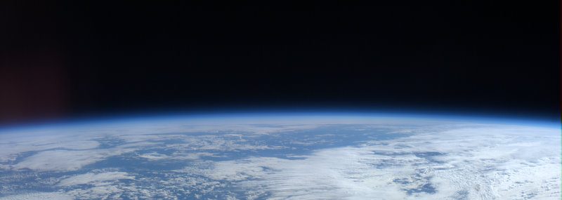
My first view of the day of the North Sea, while I was up on top of Grosmont.
The lane eventually led me into the village of Littlebeck and from there quickly into the forest that stands adjacent. It was beautiful, but extremely muddy, almost dangerously so, and brought to mind some of the slogging I did on the way to Richmond in the rain. I deployed one of my poles to help me navigate the numerous areas on the path that were total mud puddles, slop, trampled and churned up dirt. It was slow going and at this point I ended up in a middle of a group of Australians (a new group, they were from Melbourne) who were also slowly trying to pick their way through the muck. It was necessary to really pay attention to where you put your feet and especially how you shifted your weight. A misstep was easy and the result would be a complete and total mud bath! It seemed that my boots got about two pounds (each) heavier along this trail. But the forest was incredible and reminded me of spots here and there earlier during the walk in the Lake District walking through other incredible green and peaceful spaces like this. England does not have huge stands of forest any more and the Littlebeck woods were very popular. Despite the trail conditions and it being a weekday, there were a lot of people out. (I passed someone with sandals on and I felt bad for them- that was not going to end well!)

A typical scene greeting me while walking through Littlebeck woods.
Emerging from the woods alone, having lost the Australians at the cute tea room right in the middle of the traverse through the wood, I stopped for a minute to take a drink and check my maps. My next challenge was to navigate through different stretches of moor that were reputed to have some incredibly healthy boggy areas in them. Now I was reminded of my exhilarating and challenging day over the Yorkshire Dale moor with its tricky footing and poor path definition. Even though the areas I were about to cross were not as isolated, they promised a repeat of the “find the path and avoid that bog” game that I had already played once. Looking at my book, my map, and getting my compass ready, I waded in (almost literally!). Fortunately, as I had experienced earlier in the trip, the landscape was fairly dry and the “boggy” was not too bad, even though the “very boggy”, as it was marked on the map, created some opportunities for wet boots and tricky navigation. What was confusing, in the second moor I crossed, was that there were all kinds of paths gong this way and that and I really had to pay attention to ensure I was on the right one; especially when having to deviate to get around a huge bog in the middle of the path. It was fun and I still love the moorlands the best (although I am grateful that they were not full on wet because that would have been a VERY interesting experience!)

Me at the mid-point of the traverse through the woods. I get muddier later.
Clearing the moors I was back on country lanes and wondered through a few pastures before reaching a lane that led directly to the coast line, intersecting about 2.5 miles north of Robin Hood’s Bay. Like in St. Bees at the beginning of the Coast to Coast, the final part of the trail hugs the coast line before dipping into the village. When emerging from the lane and standing on the path at the cliff on the coast, my mind was telling me I was done- I had reached the North Sea, but my book and map told me otherwise. I still had to meander down to Robin Hood’s Bay. So close, but not there yet! It was a nice day and the walk was pleasant but at every turn I was anticipating the finish and the hike, while beautiful, seemed to go on forever. After nearly seven hours of tramping through ups, downs, mud, pasture, moors and bogs, rocky paths, and country lanes, I was done, but the path was not. Bummer!

Today's navigation challenge. Get through here and end up in the right place on the other side.
Finally I arrived at Robin Hood’s Bay, which is a small cozy village right on the bay. There is an upper town and an older lower town, which is where the walk officially ends, right at the beach. Of course the descent to the lower town was very steep, not so much of a problem going down, but my B&B was at the top, so I would have to climb up again. Nonetheless I wanted to go all the way to the end so I strolled down to the ocean and just sat there for a minute, amazed I actually got to that point. Yay!

This is an example of "very boggy". Most bogs did not have pools of water, but they were deceptive and it was easy to sink in over your foot.
Tradition has it that you have to go to Wainright’s Bar, in the Bayview Hotel right at the end of the walk. Not being one to buck tradition, I headed into the pub for a drink. Of course entering, I was greeted with a loud "Hello" as I knew some of the people already gathered there- they were some of the people that I had been walking with for the last week, off and on. We celebrated with a beer, shared stories, and then started splitting up to go our different ways. That, more than anything else, signaled to me the end of the adventure.

North Sea coastline. Beautiful but I was not done yet.
Not having eaten anything since breakfast, my priority shifted to getting cleaned up and finding a place to plant myself to write this blog, eat and watch tonight’s soccer game (Wales vs Portugal). Tomorrow on to Edinburg to spend a few days there before returning home and back to reality.

First view of the village of Robin Hood's Bay. The trek ends on the beach.
The Coast to Coast is not easy, but it is doable and I would recommend it to anyone who wants to see some spectacular landscape, meet some wonderful people, both the walkers and the locals, and challenge themselves. (You have to do active navigation and cannot just plod along blindly!) Even though it became a bit of a blur as I trudged my way across the coast, the experiences I had and the people I met stand out. I may not remember, exactly, which day I was in Reeth, but I do remember being at the Buck Inn (there is a Buck Inn in almost every village!) having a wonderful meal and talking with several other tables of acquaintances and friends that I made. As a matter of fact it is where I said good-bye to my friends from Sydney. I will not remember a particular view, but the incredible scenery in general, the picturesque views from the Lake District, the wildness of the Yorkshire Dales, the manicured pastures (and the sheep) and the dramatic cliffs and high moors of east Yorkshire. What a wonderful trip!!!!

Celebration! Finished!!!!!
Congrats Sandy. You never cease to amaze me. Thanks for sharing your experiences long the way. Wish I could’ve been there. Have a safe trip home. Hope to talk to you then.
Gary